Kefalonia, Poros

More about Kefalonia
KefaloniaKefalonia (Poros)
Kefalonia Hotels
Kefalonia Images
Kefalonia Images (Poros)
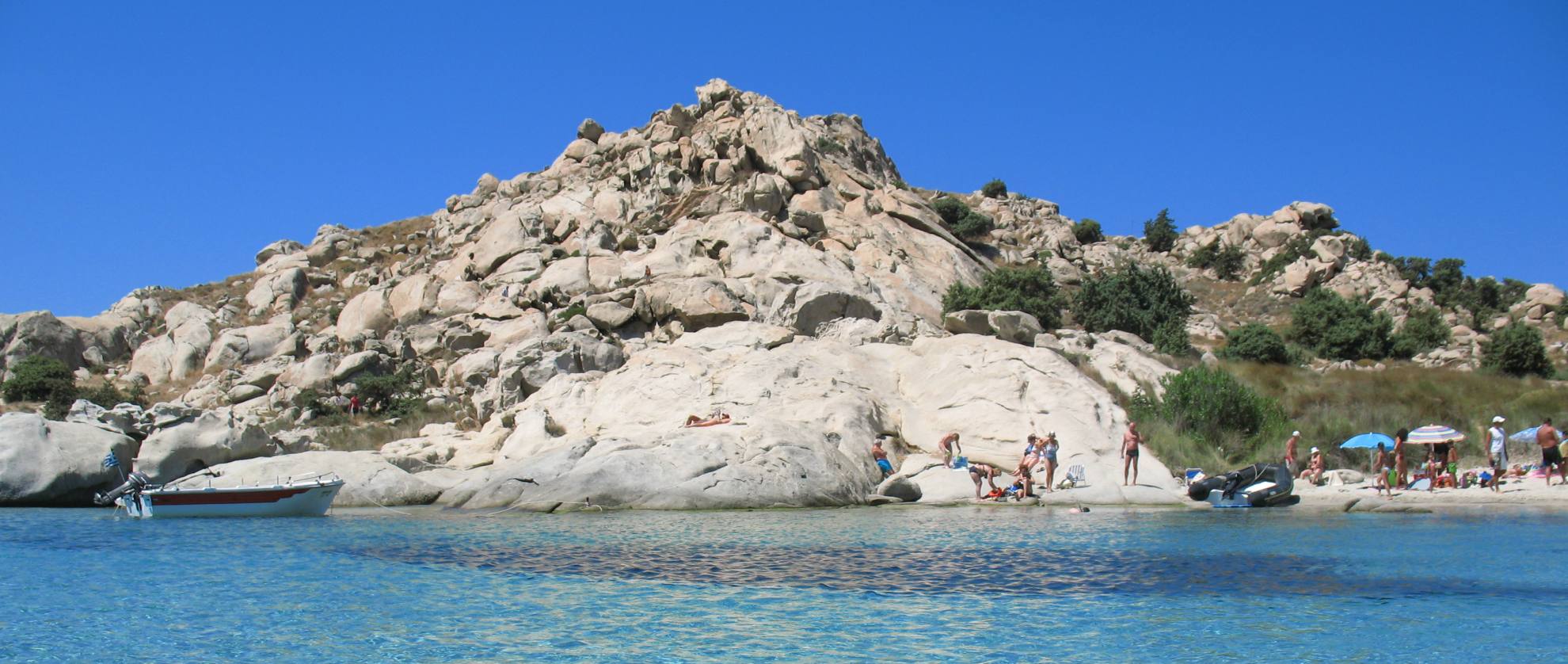
Poros is a picturesque landscape, full of mountains, ravines and beaches on the south-east edge of Kefalonia, which wins the liking of every visitor. Poros started developing after the earthquakes of 1953 which took place on the island.
Today, Poros is one of the main ports of the island, a seaside and busy town, a perfect place with a unique combination of colours of the nature such as green and blue. It guarantees ideal holidays full of relaxation, calmness and fun in a kind and hospitable enviroment.
Its port is a significant link between Kefalonia and mainland Greece. It was rebuilt after the earthquake of 1953 , after the few fishermen’s houses were destroyed, it is harmonically constructed at the foot of the mountains Pahni and Atros. A vast indented coastline, that is 2km long, abundant in sandy beaches and leeward ports, comprises its seafront.
The area is renowned as a fishing place, while its caves are a shelter for the seal Monachus-Monachus and the turtle Caretta-Caretta.
Sights
 The ravine of Poros is one of the most beautiful geological phenomena of Kefalonia. It is an 80 meter deep precipice, with steep slopes. This wild and imposing landscape is connected to a strange legend, that claims that the hollows in the rocks are the footprints of the huge supernatural feet of the hero Hercules.
The river Vohinas, noisy in winter and covered by plane trees in summer passes through Poros. It springs from lake «Avithos» (which means «bottomless»), because of its immeasurable depth.
The rich valley of Tzannata coupled with the pine covered mountain Enos, enriches the sight of Poros. At this point, its worth mentioning the black pine and the wild horses that live on this high mountain.
A short road takes you out of Poros following a north west direction and after it passes for 3 klm along a magestical beach, it goes upwards to the mountain Atros and ends at the monastery of the Virgin Mary of Atros, at the top of an impressive triangular hill, 500 meters high,. It is the oldest monastery of Kefalonia. The view from the monastery is stunning especially during sunrise.
An exquisite sample of the Kefalonian architecture is the Office of the Community and the theatre of Poros, where various cultural activities and performances of theatrical and musical groups are held during summer
Walking paths - Duration 3 hours - easy trail
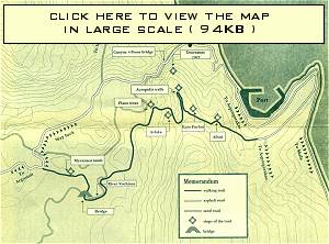 Starting point - On the way to Asprogeraka
From the settlement of Poros we follow the centrabcornice
to the harbor, and before arriving to it we turn right to
Asprogerakas. From there we follow the upward asphalt road.
When we reach the end of the asphalt we keep on, towards the
sand road around the hill. The inner space is revealed to us:
from Peloponisos, Oak island, with the Aitolo-Akarnania
coastline, Echinades cluster, up to lthaca and the strait to
Kefalonia. We reach the signpost that marks the end of Poros
settlement and ten meters away we turn right to the narrow
sand road.
First stop - The last houses
We leave the last houses on the right and viewing towards Ithaca, we follow the narrow sand road through scattered olive-trees on terraces and small clumps of reeds, signs of the existence of water especially in spring and winter.
We follow the upward cement road and at its end on our right we meet the first signpost of the trail (0 -> l) We keep ascending through bush-vegetation that consists mainly of
bushes and myrtles, arbutuses, hollies, and aromatic sage. On
our left we can see huge quarried stones.
Second stop - To Afrati
On our right we find sign (1 -> 2) and follow the trail. We
see scattered curved stones, remnants of an ancient settlement.
Continuing right, we arrive at the marking signpost and enjpy
the view towards Poros and the inner space. We return to the
path and ascending on our right, we come out to the patch of
a clearing. Again we ascend, to the coppice next to the big
cypress tree. We follow the trail signpost (2 -> 3)
Third stop - Kato Pachni
(The lower part of Pachni. Pachni is translated to Manger in English)
Ascending we reach an open flat bed and as we go on we
see scattered remains of ancient constructions which
comprised part of the ancient stronghold and ditches from
recent excavations in the area. We enjoy the view towards
Poros seaside and returning we pass again through the
downhill path. Opposite to us stands the mountain of Atros.
Fourth stop - Acropolis walls
At the crossroads we follow signpost (3 -> 4) and we find
ourselves into the interior of the ancient forts. Its rem~in~are
seen down on our left at the level of our feet. The remains that
exist indicate an once highly populated area. On our left at the
signpost we can see see the remains of the entrance gate to the
acropolis. We climb carefully on the rocks that stand in front of
us on the left side and relish the view towards all ends of the
horizon: Atros with the monastery building, and the tower-
fort, the bluff rocks, the wooded hills and the scattered olive
groves, the river bed of Vochinas with the plane trees. In the
background the head-Iake of Tzanata can be seen. But beyond
all Ainos dominates with its grand size and the Kefalonian Fir
(National Park -protected area). From here someone can
easily observe the four seas: The strait to Zante, the Patraic
gulf, Echinades, the firth of Ithaca. That is a point of strategic
importance. We return to the crossroads.
Fifth stop - Descending the Channel
We follow signpost (4 -> 5) through bush-vegetation and
continue the crossing, under the shade of Hollies, Arbutus and
Mastic trees. We meet signpost (5 -> 6) descend on the right
and, leave the path and start climbing down the Channel
towards Vochina. Small clearings alternate with thick
vegetation while we descend with little crossings on the right
side of the Channel.
Remnants of ancient constructions, retaining walls and
embankments are lying in front of us. We feel the dew. Right
and ahead, we can observe the foot of the big rock of Poros
Canyon. We reach the clearing and the small flat area.
Sixth stop - At the spring and the plane trees
The signpost on our
right hand side shows the
continuance of the trail.
We descend the channel
under the shade of the
thick vegetation. A little
bit further, three plane
trees impose their pre-
sence with their growth
and peculiar essence. We
stop for a rest at the
semicircle stone bench. Through the rock on our right, spurs
the spring with the water that abuts at the root of the
everlasting tree. Below, vividly colored oleanders and at a
short distance the carob, precious for stockbreeding. A few
meters away another old plane tree struck by lightning (the
part of its trunk that was cut can be seen). The exceptional
freshness urges for another stop at the stone bench. Beneath
there is a small cistern for watering the animals.
Stockbreeding is the most important agricultural activity of
the area, indicated by the bells and bleats of sheep and goats.
In front of us is the road of Argostoli -Poros.
Seventh stop - Vochinas
After the signpost (7 -> 8) we follow the crossing through
the vegetation, while underneath and to the right we see the
meanders of river Vochinas. We turn right and cross the
channel with the unstable material, to the opposite side, turn
right and ascend the path on the wooded hill. We pass through
the thick vegetation and come out to the clearing. Here, are
fields most of which now remain uncultivated. The trail goes
between the two hills. Then it continues downwards on our
right, while in front ofus lies the plain with the olive-grove. We
move along the narrow sand road, to a northern and
eastbound direction following the trail along the edge of the
fields. The ground becomes more even with slight grade. We
turn left and after a while on our right we meet the riverbed
with the riverside vegetation, which is an ideal sanctuary for
birds.
Eighth stop - The bridge
We continue alongside the river. On our left the fields are
cultivated mainly with cereals and legumes for covering the
needs of stockbreeding. Usually the fields are sowed in winter,
grazed as grass by the animals and later on, the crop is
harvested in order to cover the needs in the period of summer
and autumn. As the landscape widens, the presence of
agriculture becomes more vivid. At signpost (8 -> 9) we turn
right, follow the sand road and reach the bridge. Here is an
ideal spot for a short stop in the rich riverside vegetation.
Ninth stop - The Mycenaean tomb
We walk along the rural road and five minutes later, on
our right at the small hill we reach the entrance of the
Mycenaean tomb, which is a finding of great importance for
the history of the wider area.
Poros Kefalonia Useful Info
Tourist Office: 26740 72474
Port Authority: 26740 72460
Police: 26740 72410
More about Kefalonia
Discover Poros in Kefalonia


The travel guide to Greece
Contact: contact@thegreektravel.com Last update 26 April 2019